Trolltunga 2026: P2 Skjeggedal vs P3 Mågelitopp, 800 meters of ascent, and the queue for the ledge
Norway's most photographed rock ledge is a serious DNT Red hike. The Mågelibanen funicular is out of service. Here is the current reality from the trailhead to the cliff edge.
Trolltunga sits at 1,100 meters on a cliff above Ringedalsvatnet, 700 meters above the water. From P2 Skjeggedal it is 27 km return with 800 meters of elevation gain. From P3 Mågelitopp it is 20 km with the shuttle. The Mågelibanen funicular is closed. This is what the hike actually involves in 2026.
Before you book anything: the Instagram posts showing Trolltunga as a quick morning hike were taken by people who either started at 05:00 or did not tell you they started at 05:00. The full trail from P2 Skjeggedal to the ledge and back is 27 km with 800 meters of net elevation gain and closer to 1,000 meters of cumulative ascent once you factor in the plateau's rolling terrain. Most walkers take 8 to 12 hours. Some take more. The Norwegian Trekking Association grades it DNT Red. Plan accordingly.
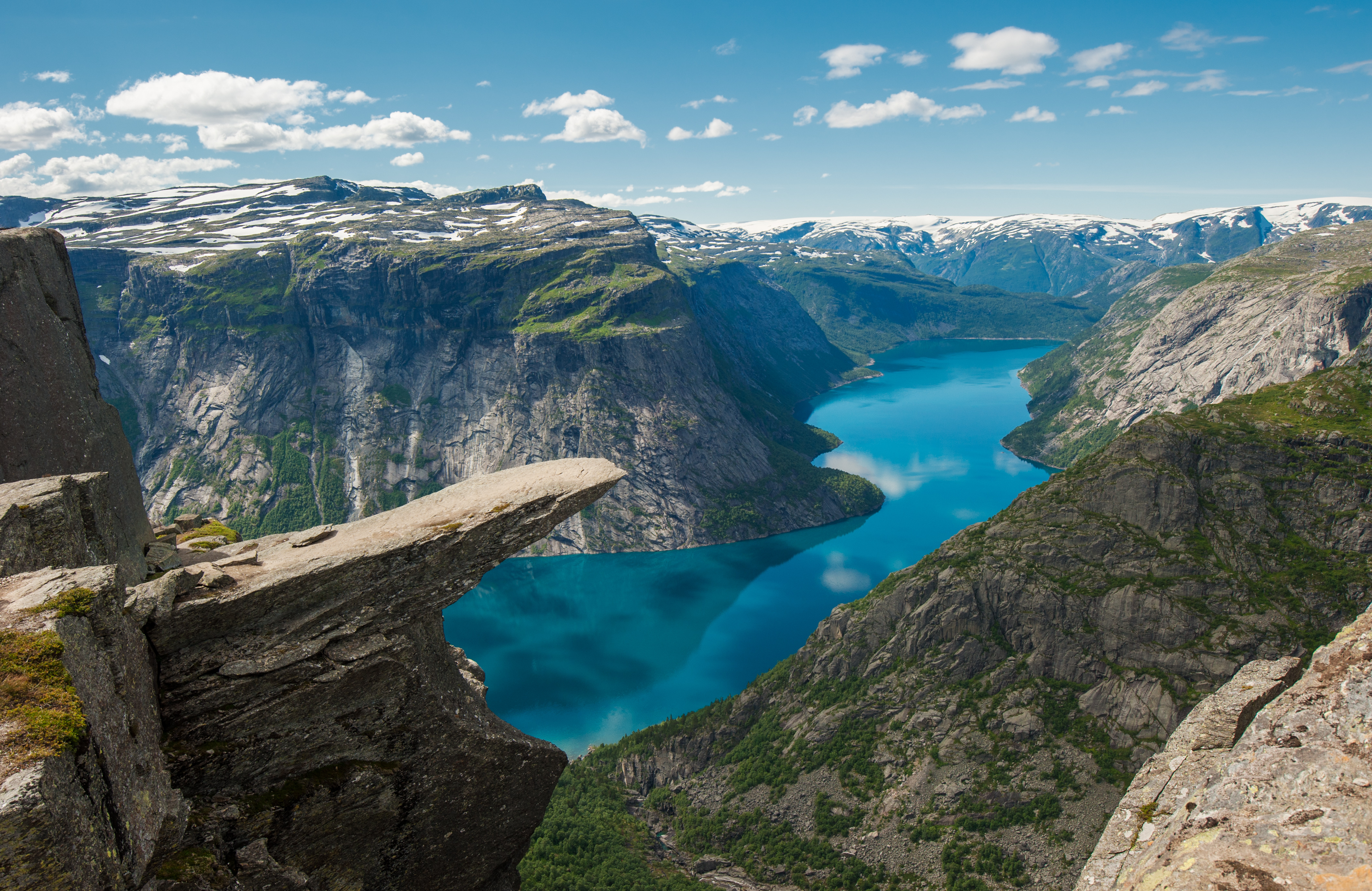
That said, Trolltunga earns its reputation. The rock ledge projects horizontally from the cliff at 1,100 meters above sea level, with 700 meters of open air between the tip of the tongue and the surface of Ringedalsvatnet below. It is a specific and genuinely remarkable piece of glacial geology formed during the last ice age, when the Hardanger ice sheet carved the valley and left this cantilevered block of gneiss behind. Around 100,000 people walk to it between June and September every year. Here is what the approach looks like now.
The Mågelibanen is closed. Here is what replaced it.
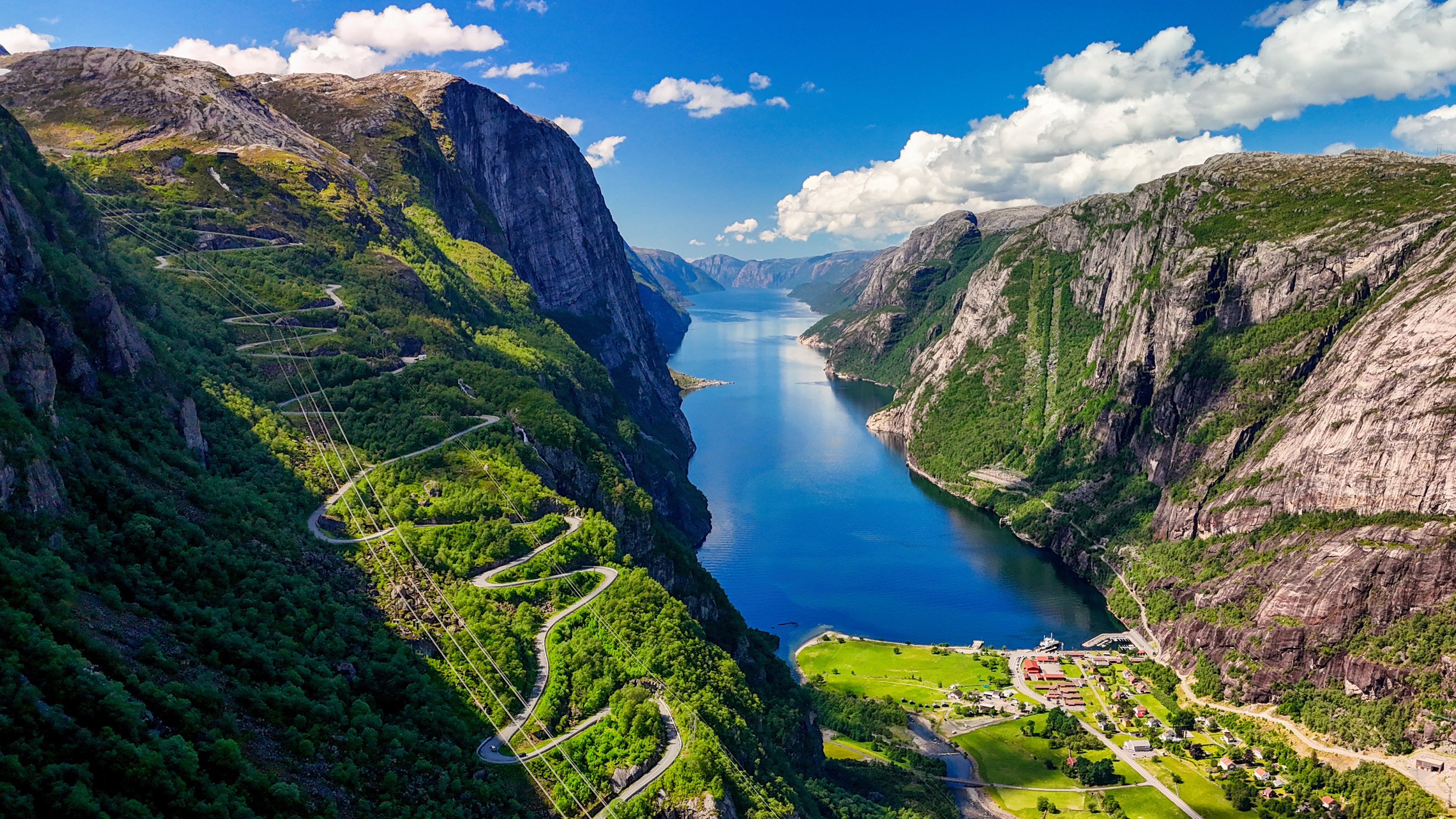
For decades the Mågelibanen funicular carried Norsk Hydro workers and later hikers up the steep first 400 meters of the ascent from Skjeggedal. It is no longer in operation and has not been for some years. Do not plan a hike assuming it exists. Older guidebooks, travel blogs from the mid-2010s, and some out-of-date tour listings still reference it. They are wrong.
What replaced it is a road up to P3 Mågelitopp and a shuttle bus that runs between P2 Skjeggedal and P3. The shuttle saves roughly 1.5 hours of uphill walking each way. The road itself is closed to private traffic unless you have pre-booked a P3 parking slot. The whole point of the shuttle system is to limit traffic on the narrow access road and concentrate the hiker flow.
Three trailheads, three different hikes
You now choose your hike by choosing your parking. The three options produce three different experiences.
- P1 Tyssedal. 38 km return, around 15 hours, 1,200 meters of elevation gain. 227 spaces. 300 NOK per day. No booking. This is the original pre-road approach and it is almost never the right choice for a day hike. Consider it only if you are genuinely through-walking from sea level as a personal objective.
- P2 Skjeggedal. 27 km return, 8 to 12 hours, 800 meters of net elevation gain. 229 spaces. 500 NOK per day (combined road toll and parking). No booking required. This is the standard trailhead and the one most guided tours use.
- P3 Mågelitopp. 20 km return, 7 to 10 hours, roughly 320 meters of net elevation gain. 30 spaces. 600 NOK per day. Pre-booking mandatory between June 1 and September 15. This is the shortest option and the one that has made Trolltunga accessible to fitter walkers who cannot commit to a 12-hour day.
If you cannot book P3 and the P3 shuttle is sold out, you are hiking from P2. That is not a disaster. Most people do.
The P2 to P3 shuttle bus
The shuttle runs between P2 Skjeggedal and P3 Mågelitopp in the 2026 season from May 23 to 24 and May 29 to September 30. It departs approximately every 10 to 30 minutes during the morning rush (06:30 to 11:00) and the afternoon return window (14:30 to 19:00). Morning buses combine pre-booked seats and drop-ins. Afternoon buses are drop-in only. Book the morning bus online at trolltunga.com to guarantee a seat if your start time is tight.
One-way fare is in the 200 to 250 NOK range. If you take the shuttle up and walk down, you convert a 27 km day into roughly 23 km with significantly less cumulative climbing.
The guided tour requirement
From October 1 to May 31 you must hike Trolltunga with a certified guide. This is enforced. The route in snow, on icy plateau, and in short daylight is genuinely hazardous without someone who knows the ground and carries proper equipment. The winter version of this hike has claimed lives in recent years. Self-guided attempts outside the summer season are the main cause.
Trolltunga Active and Trolltunga Adventures run the majority of guided departures from Odda and Skjeggedal. Summer prices start around 1,500 NOK per person for a standard guided day. Winter tours including via ferrata or overnight options run higher.
What the trail actually looks like
From P2 the first 4 km climb 400 meters on a combination of steep track and stone steps. This is the hardest continuous ascent of the day and it does not let up until you reach the top of the old Mågelibanen line. This section is where most people discover whether they have trained enough. If you are struggling badly here, the honest call is to turn back. The remaining 9 km to the ledge cross exposed plateau with no easy exit.
From the top of the climb the trail joins the route from P3 and crosses 9 km of open Hardanger plateau. The surface varies: bog bridges, stone-built causeways, bare rock, and scree. In places the trail is well marked with red T-markings painted on rocks by the Norwegian Trekking Association. In other places you navigate by cairns. Visibility matters. In cloud the plateau disorients quickly.
Two short scrambles sit near the ledge approach. Neither is technical. Both are exposed and require you to use your hands. A dropped phone here falls a long way.
At the ledge itself during peak summer the queue runs 20 to 45 minutes. In busy August periods it reaches 60 minutes. One group on the ledge at a time for photographs. The ledge is roughly 2 meters wide and extends approximately 10 meters from the cliff. The drop below is 700 meters to Ringedalsvatnet. The view down the lake toward the Folgefonna glacier massif is the reason the queue exists.
What works
- Early trailhead start. A 06:00 start from P2 puts you at the ledge around 10:00 or 11:00, ahead of the main mid-afternoon queue. Descending while others ascend means the trail is less congested and the light on the way down is better.
- Booking the P3 shuttle or P3 parking. Starting from P3 transforms the day from demanding to moderate. It also means you arrive at the ledge with energy to spare rather than empty.
- Ringedalsvatnet as a decision point. The lake sits roughly halfway up from P2. If you are exhausted at the lake, that is useful data about your remaining capacity for the plateau crossing and the return. Turning back here is not a failure. Pushing past it when you are already empty is how people end up calling Luftambulansen.
- Layered clothing and a shell. The Hardanger plateau sits at 1,100 meters and generates its own weather. Summer temperatures at the ledge can run 10 degrees colder than at Odda, and wind is the default. A shell jacket and a warm mid-layer are not optional.
What does not work
- Late trailhead start. Anyone leaving P2 after 09:00 in peak season is likely to be descending in fading light or rushing. Neither is safe on this terrain. If you cannot start by 09:00, book the shuttle to P3 and start there.
- Underestimating food and water. 27 km of mountain terrain requires a minimum of 2 liters of water and substantial food. Two sandwiches, a gel, and trail mix is a reasonable baseline. There is no resupply on the route. There is no shop at the ledge.
- Trusting phone GPS alone. Coverage is inconsistent on the plateau. Download an offline map (ut.no or Gaia GPS) and carry a paper map as backup. Fjellvettreglene Rule 7 applies: a map and compass are not optional.
- Ignoring the forecast. The Hardangerfjord region receives significant precipitation and wind shifts are common. Check yr.no the morning of the hike. If thunderstorms are forecast for the afternoon, bring the start time forward or postpone. The plateau is the highest thing for kilometers in any direction.
- Cotton base layers. Cotton holds sweat and cold. Merino wool or synthetic base layers only. This is particularly important for the return descent, when you will have sweated through the climb and are now walking downhill into cooling evening air.
Odda as basecamp
Odda is the practical basecamp for Trolltunga. It sits on the southern end of Sørfjorden, 20 minutes by road from P2 Skjeggedal. The town has roughly 5,000 residents and a full range of accommodation from hostels to mid-range hotels. Trolltunga Hotel, Hardanger Hotel, and the Trolltunga Camping site on Sandvinvatnet lake all put you within a short drive of the trailhead. Book well ahead for July and August. The town fills.
If you are driving from Bergen, budget 3.5 hours via Fv7 and Rv13. The Jondal ferry crossing shortens the route but departures are limited. From Oslo the drive is 6 hours through Haukeli. Both routes include significant tunneling.
Fjellvettreglene on Trolltunga
Four of the Nine Mountain Rules apply directly to this hike.
- Rule 2. Adapt the trip to ability and conditions. If the plateau forecast is poor, start from P3 or do not start at all.
- Rule 3. Pay attention to the weather and forecasts. Hardanger plateau weather turns inside an hour.
- Rule 7. Use a map and compass. Phones fail. Batteries die in cold.
- Rule 8. Turn back in time. No shame in retreat. The ledge will be there next summer.
Practical information (2026)
- Distance: 27 km return from P2 Skjeggedal. 20 km return from P3 Mågelitopp. 38 km return from P1 Tyssedal.
- Elevation gain: 800 m net from P2. 320 m net from P3. 1,200 m net from P1.
- Time: 8 to 12 hours from P2. 7 to 10 hours from P3. 15 hours from P1.
- DNT grade: Red (strenuous, requires hiking experience and proper equipment)
- Season (self-guided): June 1 to September 30
- Season (guided only, required): October 1 to May 31
- Parking P1 Tyssedal: 300 NOK per day, 227 spaces, no booking
- Parking P2 Skjeggedal: 500 NOK per day (includes road toll), 229 spaces, no booking
- Parking P3 Mågelitopp: 600 NOK per day, 30 spaces, online booking required June 1 to September 15
- Shuttle bus P2 to P3: Approximately 200 to 250 NOK one way, May 23 to September 30
- Guided tour from Odda: From 1,500 NOK per person in summer
- Mågelibanen funicular: Closed. Not in operation.
- Emergency: 113 medical (Norsk Luftambulanse). 112 police and rescue.
Trolltunga rewards preparation. It punishes assumption. If you train for the distance, book the parking or shuttle early, check the forecast the morning of the walk, and carry the right clothing, it delivers one of the most specific views in Norway. If you treat it as a casual day out because the Instagram photo looks easy, it is the hike that ends with a call to Luftambulansen.
The ledge has been there since the last ice age. It will still be there the day you come back better prepared.